Aerial photographs of Hammersmith & Fulham in 1940
The latest addition to the council's internet mapping service
The fascinating black and white images can be found on the council's website, by clicking the easy maps option in the A-Z.
To help you get oriented, it's possible to overlay a modern street index. There are also more up to date images in colour. But don't expect to find every detail in those 65-year-old images. As it was during the war, the images were censored so incoming German bombers didn't have such an easy time of it. Shepherd's Bush, for example, has been deliberated blurred out, as are other potential industrial targets.
The easy maps service is fully interactive allowing you to search and view maps going back to 1869 as well as planning applications and other information.
Julien Harrison-Rogers, who manages the web pages, says, "Sure it is fun to compare aerial photos from 1940 with photos taken this year but this technology also has many labour saving and practical applications. Residents can now access information on planning applications, street works and restrictions and by-laws that might affect their property 24 hours a day, seven days a week."
You can also apply map layers showing not just streets, but also administrative districts (wards), controlled parking zones and look at the zones, and more, in the unitary development plan.
All this sophistication means new users will need help, and that's available through on-line tutorials, guides, and frequently asked questions.
There is also an e-mail service if you get stuck. If you are using this
service in one of the borough's libraries or in a council reception area
where some free internet terminals are available please ask for help.
You can also e-mail easy maps support on egis@lbhf.gov.uk
July 31, 2005
Related links
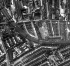 The Arc in 1940 and... 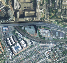 ...today |
|
| Related Links | |
| Participate | |
| Sign up for our free weekly newsletter Comment on this story on the |